نکاتی برای ایجاد عکس های شگفت انگیز از منظره
سپتامبر 27, 2019
3462
بدون دیدگاه


You must need to login..!
مکان ، مکان ، مکان
بدیهی است ، هنگام عکاسی از یک منظره عالی ، تنها مهمترین چیز ، خود منظره است! محل موقعیت.
از نظر خلاقیت ، در اینجا جایی است که من فکر می کنم بیشتر عکاسان از ابتدا خود را با پای پیاده شلیک می کنند. آنها بارها و بارها به همان نقاط نمادین می چرخند. قوس ظریف. مارون بل. خم Oxbow و غیره بله ، این مکانها به دلایلی نمادین هستند – جالب توجه هستند! اما مشکل اینجاست که در این روز و سن ، همه ما این عکس ها را هزاران بار دیده ایم. در اکثر موارد ، بهترین موردی که یک عکاس می تواند در این مکانهای نمادین به آن امیدوار باشد ، گرفتن چیزی “به همان اندازه” بهتر از آنچه قبلاً دیده شده بود ، یا شاید اگر شرایط آب و هوا و نور واقعاً پدیده باشد کمی بهتر باشد. اما معمولاً ، قبل از فشار دادن کرکره ، عکسها از قبل خسته شده اند.
اگر از رفیق عکاسان همکار خود لذت می برید و سعی می کنید لیست گزینه های نمادهای مشهور را تیک بزنید ، شاید این یک پیگیری جالب باشد. اما اگر بیشتر علاقه دارید که آبهای خلاقانه تان سرازیر شود ، من پیشنهاد می کنم که از مسیر ضرب و شتم دور شوید. این بدان معناست که آیا این به معنای گذراندن یک مسیر جانبی کوتاه از بوته ها به دور از دیدگاههای مستقر است یا پیاده روی روزها در بیابان برای دوری از همه اینها ، پیدا کردن نقطه شخصی شما اولین قدم در روند خلاقانه عکاسی منظره است.
برای من ، این بخش عظیمی از روند است و بیشتر از همه سرگرم کننده بودن آن است. من خوشبخت هستم که وقت و سلامتی دارم که بتوانم در کوهستان مسیرهای کوله پشتی طولانی را طی کنم ، و واقعاً این همان کاری است که از انجام عکس لذت می برم ، به همان اندازه یا حتی بیشتر از عکس گرفتن. من قبل از اینکه حتی یک دوربین داشته باشم ، کوله پشتی را دوست داشتم و هنوز هم آن را دوست دارم. عکاسی فقط بعد و انگیزه دیگری را به تجربه می افزاید. مزیت برای عکاس پیاده روی این است که آنها می توانند به مکان های خود برسند – مکان هایی که عکسی از آنها گرفته نشده است تا مرگ ، مکان هایی که او یا او می توانند مناظر با چشمان تازه ببینند و می توانند آهنگهایی را انتخاب کنند که قبلاً انتخاب نشده بودند.
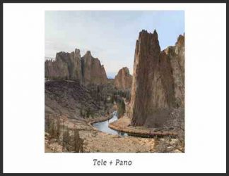
Misty Teton Reflection B / W
همه ما نماهای کلاسیک تتون ها را از دره جکسون هول مشاهده کرده ایم – آنها واقعاً دیدنی هستند. اما من تجارب و چالش های پیاده روی را به این محدوده ترجیح می دهم تا مکانهای دیدنی کمتری را دنبال کنم. دوربین میدانی چوبی Tachihara 4 × 5 ، Nikkor 135mm ، grad GND ، Provia ، طبل اسکن شده و تبدیل به b / w در Photoshop)
جرقه خلاقیت اولیه بیشتر عکسهای من قبل از اینکه حتی کوله پشتی خود را روشن کنم اتفاق می افتد. من زمان زیادی را صرف تحقیق در مورد مسیرهای جدید می کنم و پیاده روی ها و نماهای گذشته را به یاد می آورم ، در حالی که سعی می کنم صحنه های بالقوه را در نور بالقوه مشاهده کنم. سه ابزار بسیار قدرتمند که من برای این کار استفاده می کنم:
1) Topo National Geographic! نرم افزار نقشه برداری دارای کلیه نقشه های topo USGS برای یک حالت معین است که در یک برنامه کاربردی آسان با هم یکدست شده است. من می توانم مسیرهایم را ترسیم کنم و مسایل پیموده شده و ارتفاع را به من بگوید. سپس می توانم فقط بخشهایی را که برای سفر خود نیاز دارم چاپ کنم. این بهترین روش برای برنامه ریزی یک سفر است. با داشتن تمام نقشه های رایانه خود ، دیگر برای ایده های سفر نیازی به کتابهای راهنمای ندارم – فقط نقشه های توپو را باز می کنم و مسیرهای خودم را انتخاب می کنم. توپو گران است ، اما گزینه های آنلاین رایگان شامل Caltopo.com ، Hillmap.com و Mappingsupport.com است.
Location, location, location
Obviously, when photographing a grand landscape, the single most important thing is the landscape itself! The place. The location.
In terms of creativity, here’s where I think most photographers shoot themselves in the foot from the start. They swarm to the same iconic spots, over and over and over again. Delicate Arch. Maroon Bells. Oxbow Bend. Etc. Yes, these places are iconic for a reason – they are spectacular! But, the problem is that in this day and age we’ve all seen these photos thousands of times before. In most cases, the best a photographer can hope for in these iconic locations is getting something “as good” as what they’ve already seen before, or maybe just a little bit better if the weather and light conditions are truly phenomenal. But usually, the photos are already stale before the shutter is even pressed.
If you enjoy the camaraderie of your fellow photographers and strive to tick the checklist of all the popular iconic views, then perhaps this can be a fun pursuit. But if you’re more interested in getting your creative juices flowing, I would suggest straying from the beaten path. Whether it means taking a short side path through the bushes away from the established viewpoints, or trekking for days into the wilderness to get away from it all, finding your own spot is the first step in the creative landscape photography process.
For me, this is a huge part of the process, and most of the fun of it all. I am fortunate to have the time and health to go on long backpacking treks in the mountains, and indeed this is what I enjoy doing, as much or even more than taking photos. I loved backpacking before I even owned a camera, and I still love it. Photography just adds another dimension and motivation to the experience. The bonus for the hiking photographer is that they can get to their own locations – places that haven’t been photographed to death, places where he or she can see landscapes with fresh eyes and can choose compositions that haven’t been chosen before.
Misty Teton Reflection B/W
We’ve all seen the classic views of the Tetons from the Jackson Hole valley – they are indeed spectacular. But I prefer the experiences and challenges of hiking into the range to pursue lesser known vistas like this. Tachihara 4×5 wood field camera, Nikkor 135mm, GND grad, Provia, drum scanned and converted to b/w in Photoshop)
The initial creative spark of much of my photography happens before I even put my backpack on. I spend a lot of time researching new routes and remembering past hikes and views, all the while trying to envision potential scenes in potential light. There are three very powerful tools I use for this:
1) National Geographic’s Topo! mapping software has all the USGS topo maps for a given state stitched together seamlessly in one easy to use application. I can draw my routes and it will tell me the mileage and elevation gains. Then I can print out only the sections I need for my trip. This is the best way to plan a trek. Having all the maps on my computer, I don’t need guidebooks anymore for trip ideas – I just open the topo maps and pick my own routes. Topo! is expensive, though; free online alternatives include Caltopo.com, Hillmap.com, and Mappingsupport.com.
10 تکنیک مهم عکاسی با موبایل برای افراد مبتدی برای دانلود رایگان 10 تکنیک مهم عکاسی با موبایل برای افراد مبتدی با کیفیت 1080p از پلیر سایت یا لینک ز�
عکاسی حرفه ای با گوشی xiaomi redmi note 8 pro برای دانلود رایگان عکاسی حرفه ای با گوشی xiaomi redmi note 8 pro با کیفیت 1080p از پلیر سایت یا لینک زیر استفاده کنین لینک
آموزش چگونگی عکاسی از ماشین با گوشی هوشمند برای دانلود رایگان آموزش چگونگی عکاسی از ماشین با گوشی هوشمند با کیفیت 1080p از پلیر سایت یا لینک زیر ا
آموزش ایجاد افکت نوارهای VHS رو ویدیو در Premiere برای دانلود آموزش ایجاد افکت نوارهای VHS رو ویدیو در Premiere با کیفیت full hd 1080p از پلیر سایت یا لینک زیر
طریقه کار کردن با Mask و Saturation در photoshop(فتوشاپ) برای دانلود آموزش طریقه کار کردن با Mask و Saturation در photoshop(فتوشاپ) با کیفیت full hd 1080p از لینک زیر یا پلیر س
توضیحاتی درباره سیستم رنگی RGB , sRGB , CMYK و… برای دانلود آموزش توضیحاتی درباره سیستم رنگی RGB , sRGB , CMYK و… با کیفیت full hd 1080p از لینک زیر یا پلیر سایت اس�